Grande Prairie sits on a thick package of glacial till, glaciolacustrine clays, and buried preglacial valleys carved into Cretaceous shale and sandstone. Mapping the depth to competent bedrock here is rarely straightforward—boreholes alone can miss abrupt lateral changes, and the clay-rich overburden masks subtle stratigraphic traps. A seismic refraction survey adds continuous P-wave velocity profiles that reveal top-of-bedrock, while MASW supplements the dataset with shear-wave velocities for seismic site class determination per NBCC 2020. For projects near the Smoky River or within the city’s expanding industrial parks, we combine refraction and reflection tomography to image the subsurface with the vertical and lateral resolution that engineering design demands.
A velocity tomogram can reveal a buried preglacial valley that conventional drilling would miss entirely—and that valley may control groundwater flow and settlement behaviour.
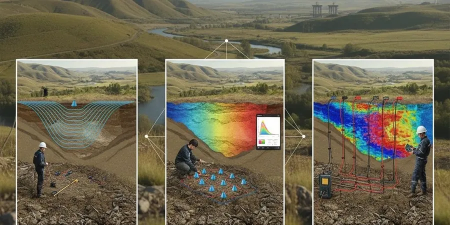
Methodology and scope
Local considerations
Grande Prairie lies within a region of moderate seismic hazard (NBCC Sa(0.2) values around 0.08–0.12 g), but the real risk for most projects is not earthquake shaking—it is undetected soft zones within the glacial sequence. A 2021 trench collapse in the County of Grande Prairie was traced back to a buried clay-filled channel that standard borehole spacing had not identified. Seismic refraction tomography maps these features laterally, reducing the chance of differential settlement beneath mat foundations or rigid pavements. Without velocity control, contractors can also misjudge rippability, leading to costly change orders when excavators encounter unexpectedly hard shale. Our tomograms provide a defensible basis for earthwork specifications and geotechnical baseline reports, aligning with the risk-management framework expected by infrastructure owners and their insurers under CSA A23.3 and the current NBCC.
Applicable standards
ASTM D5777-18 (seismic refraction), ASTM D7128-18 (seismic reflection), NBCC 2020 (seismic hazard and site classification), Alberta Transportation Technical Standards Branch Spec. 5.7, CSA A23.3
Associated technical services
Seismic Refraction Tomography
P-wave and S-wave profiling for bedrock mapping, rippability assessment, and Vs30 calculation. Ideal for linear infrastructure, pad sites, and borrow-source evaluation.
High-Resolution Seismic Reflection
Imaging stratigraphic boundaries and buried channels beyond 30 m depth. Used for deep utility tunnels, bridge pier investigations, and groundwater basin studies.
Combined Refraction-Reflection Surveys
Integrated acquisition and joint tomographic inversion that delivers both shallow velocity structure and deep impedance contrasts from a single spread deployment.
Tomography for Seismic Site Classification
Direct measurement of Vs30 and Vs profiles for NBCC 2020 site class determination, supporting structural design and liquefaction screening.
Typical parameters
Frequently asked questions
How deep can seismic tomography investigate in the Grande Prairie area?
Refraction surveys with a 276-metre spread typically reach 40–50 metres depth in the local glacial till, while reflection profiles can image horizons below 100 metres. Depth depends on spread geometry, source energy, and velocity structure. For very deep targets we use an accelerated weight drop or combine reflection with downhole velocity logging.
What is the typical cost of a seismic refraction survey in Grande Prairie?
Most projects in the Grande Prairie region fall between CA$3,220 and CA$6,800, depending on line length, number of spreads, terrain access, and whether reflection acquisition is added. Mobilization from Edmonton and crew subsistence are included in the estimate.
Can seismic tomography replace boreholes?
No—tomography provides continuous lateral coverage but requires borehole or test-pit control to calibrate velocity-to-lithology conversions. The best practice is a phased approach: seismic lines first to optimize borehole locations, then targeted drilling to ground-truth the tomogram.
Does winter weather affect seismic data quality in the Peace Country?
Winter actually improves coupling for surface geophones once the active layer is fully frozen, reducing ambient noise from wind and traffic. We work year-round with cold-rated cables and batteries; the main constraint is daylight hours and extreme cold below -30°C, which can shorten recording windows.