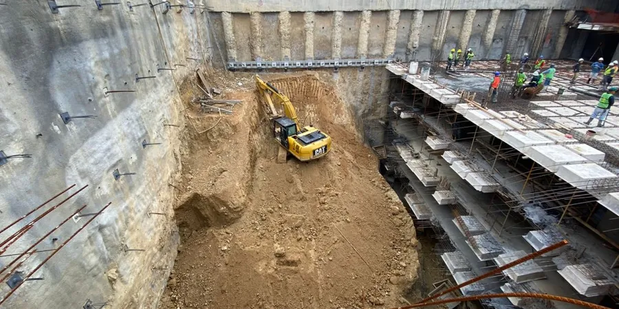
A seven-story mixed-use project on 100 Avenue required a three-level underground parkade in downtown Grande Prairie. The contractor hit dense glacial till at 4 meters, but groundwater started seeping in at just 2.8 meters below grade. This scenario repeats across the Peace Country: competent soils up top, unpredictable water pressures underneath. Our lab team has been called in for test pits to verify overburden stratigraphy and in-situ permeability testing to determine dewatering needs before shoring design even starts. With a population surpassing 64,000 and growing, Grande Prairie's commercial core demands deeper underground space, and each excavation presents a unique puzzle of soil behavior and lateral earth pressure that must be solved with site-specific design rather than generic solutions.
Dense glacial till can stand vertically for days, but a single rain event changes everything—we design for the worst-case saturated condition, not the best-case dry cut.
Methodology and scope
Local considerations
The NBCC 2020 requires that excavations deeper than 6 meters be designed by a professional engineer with geotechnical input, and Grande Prairie's layered stratigraphy makes this non-negotiable. We have seen projects where contractors assumed a uniform clay profile, only to encounter a buried gravel channel—an old meltwater deposit—that collapsed the cut and flooded the site within hours. The Peace River region's rapid spring thaw creates another hazard: frozen ground masks seepage paths that open violently when the ice lens melts, leading to sudden loss of passive resistance at the toe. Our design methodology accounts for the full seasonal cycle, specifying staged excavation sequences, instrumentation thresholds for inclinometers and piezometers, and contingency plans for mixed-face conditions where till transitions into water-bearing gravels. The cost of underestimating lateral earth pressures here is not theoretical; it shows up as delayed permits, cracked adjacent foundations, and worker safety stand-downs that erode project margins.
Applicable standards
NBCC 2020 – National Building Code of Canada, Part 4 Structural Design, CSA A23.3:2019 – Design of Concrete Structures (Annex N for excavation support), ASTM D4767-11 – Standard Test Method for Consolidated Undrained Triaxial Compression Test for Cohesive Soils, FHWA-NHI-10-024 – Earth Retaining Structures (U.S. DOT reference for soldier pile and tieback design), CAN/CSA-S6-19 – Canadian Highway Bridge Design Code (CHBDC) for temporary works loads
Associated technical services
Shoring Wall Design & Analysis
We develop soldier pile and lagging, secant pile, or sheet pile wall designs with staged excavation sequences. Lateral earth pressure diagrams follow the apparent pressure envelope method, calibrated to local till stiffness from pressuremeter and dilatometer data. Each design includes a deflection prediction, strut load table, and embedment depth verification against basal heave and piping.
Dewatering & Groundwater Control Plans
Grande Prairie excavations frequently encounter perched water in sand lenses within the till, plus basal flow from preglacial gravels. Our dewatering designs specify well spacing, pump capacity, and drawdown targets, supported by pumping test analysis and MODFLOW-based numeric simulation when the site footprint exceeds 1,000 m². We also prepare the sediment and erosion control plan required by Alberta Environment for construction dewatering discharge.
Typical parameters
Frequently asked questions
What is the typical cost range for geotechnical design of a deep excavation in Grande Prairie?
For a complete design package—including site investigation, laboratory testing, shoring wall design, dewatering plan, and construction-phase monitoring specifications—budgets in Grande Prairie generally fall between CA$2,490 for smaller, straightforward cuts and CA$12,680 for complex, multi-level excavations with adjacent buildings and high groundwater. The final figure depends on the depth, soil variability encountered, and instrumentation requirements.
How does the glacial till in Grande Prairie affect excavation support design?
The till here is dense and overconsolidated, which gives it good stand-up time in the short term, but it is also fissured and contains cobbles and boulders. The fissures reduce the operational cohesion when the cut face is exposed to wetting-drying cycles, and boulders can deflect sheet piles during driving. Our designs use a reduced effective cohesion envelope and often specify pre-drilling for pile installation to manage refusal risk.
Do you handle the construction monitoring phase after the design is complete?
Yes, we provide construction-phase services that include review of shoring submittals, periodic site visits to verify that excavation and bracing proceed according to the staged sequence, and interpretation of inclinometer and piezometer data against the design thresholds. If ground movements exceed the predicted envelope, we can issue field directives for additional struts or revised excavation berms within 24 hours.